Friday, December 7, 2012

Hovenweep :: Square Tower Group

I found Hovenweep National Monument to be a fascinating place. Viewing the multi-storied towers perched on the canyon rims and balanced on boulders, I was amazed by the structures and by the people who had built them. Experts at masonry and engineering, the builders used the rock slabs for foundations and the walls of the structures were laid down over the uneven surfaces, rising, in some cases, to heights of several stories.

Why were they built on the rocks? Why were they built in a variety of shapes – squares, ovals, circles, and D-shaped? What was the purpose of the buildings? What happened to their builders?

According to literature from the National Park Service:
The towers of Hovenweep were built by ancestral Puebloans, a sedentary farming culture that occupied the Four Corners area from about A.D. 500 to A.D. 1300. Similarities in architecture, masonry and pottery styles indicate that the inhabitants of Hovenweep were closely associated with groups living at Mesa Verde and other nearby sites.

The ancestral Puebloans prepared their land for cultivation much like farmers do today. They created terraces on hillsides, formed catch basins to hold storm run-off, and built check dams to retain topsoil that would otherwise wash away. Storage granaries under the canyon rims protected harvests of corn, beans and squash for later use.

Many theories attempt to explain the use of the buildings at Hovenweep. The striking towers might have been celestial observatories, defensive structures, storage facilities, civil buildings, homes or any combination of the above. While archeologists have found that most towers were associated with kivas (Puebloan ceremonial structures), their actual function remains a mystery.

By the end of the 13th century, it appears a prolonged drought, possibly combined with resource depletion, factionalism and warfare, forced the inhabitants of Hovenweep to depart. Though the reason is unclear, ancestral Puebloans throughout the area migrated south to the Rio Grande Valley in New Mexico and the Little Colorado River Basin in Arizona. Today's Pueblo, Zuni and Hopi people are descendants of this culture.
The Square Tower Group, located in and around Little Ruin Canyon, which is a short walk from the visitors center, has the largest collection of ancestral Puebloan structures at Hovenweep. The remains of nearly thirty kivas have been discovered as well as a variety of other structures. They think that it is possible that as many as 500 people occupied the Square Tower area between A.D. 1200 and 1300.

The Stronghold House as seen from across the the canyon, from the south side.

These are the same two buildings in the previous photo, taken from a slightly different angle. Using the zoom distorts and compresses the view somewhat.

Two towers, looking northwest.

The same two towers, looking northeast.

Detail showing the stonework.

Hovenweep House, the largest structure in the area, along with several outbuildings. As seen from the south side of the canyon.

Hovenweep House, on the edge of the canyon. Looking to the east.

The Square Tower. Perched on a boulder, at the bottom of the west end of the canyon.

Ruins Canyon, looking east. The two towers are just below the rim of the canyon near the center of the picture. Several other structures dot the landscape, almost blending in with the boulders.

Photographs taken on May 19, ...

Wednesday, December 5, 2012

Coco the Super Hero

I wrote about the less than obedient Coco the other day, and while resizing some pictures, I realized that although she has her own agenda at times, she is so much fun to take hiking because she turns into a super hero when we go.


We could sit and watch her run for hours.


We think it is especially cool to watch her leap into the air while jumping over things:


And then there is that not so obedient part again...where she runs into the water and drinks it...and gets sick from it. Leaving messes that Nathan has to clean up. She knows she is in trouble:


And being the dutiful grandmother, I have to share a beauty shot of her. I'm forcing myself to shoot in manual mode since I'm about five years overdue on it, and she is doing a great job of being my favorite model for the time being.

Ok, enough about the dog. Because although I love this dog, it is pretty ridiculous when I have two blog posts about her this week and none of the kids!


Living the life in oh so sunny and WARM Florida!

Tuesday, December 4, 2012

Why do hard and dangerous climbs?


Learning moves on a project. Photo: Steven Gordon

We can all readily appreciate the beauty of rock and the shapes it gives to the world, we just have to travel through the landscape. If we want to dig deeper, we can travel over mountains and look at them. A visual interaction with the rock.

Rock climbing is a deeper interaction with the rock. The medium of movement on rock allows us to crack open the beauty of rock not fully visible to the eye and get more back.

The harder the rock climb, the more we have to understand the rock to move, the more we learn. The more dangerous the rock climb, the more we have to understand the rock so we can stay alive.

The hardest and most dangerous climbs are the most meaningful, but they come at a cost most rock climbers wouldn’t dare to pay. Every climber finds their own balance of cost and reward.


Friday, November 30, 2012

Albuquerque International Balloon Fiesta

Today was the last day of the balloon fiesta this year. I didn't get to see any balloons up close except for the one in the following post. These photos were taken about 8am.


Darth Vader in the center


Wells Fargo Stagecoach


And they were gone.


Tuesday, November 27, 2012

The Gift WI4R, First Ascent SWPA

Laura and I made a last minute decision that based on the poor (warm) future SWPA forecast, we needed to climb whatever we could find, before it was gone! We quickly agreed that Sunday School Crag would be our destination since it resides at a higher elevation than most other SWPA crags. It also receives little to no sun. If anything was "in" it would be Sunday School. On New Year's Day Laura and I hiked in to try to climb, but poor conditions kept us off the ice. We took note of a line that was forming just right of the line we did last year Late Bloomer. It looked like a lot of fun, but we figured it was better left for safer conditions. Today was that day, although the conditions weren't much safer. When we left home it was humid and the thermometer was reading 31°. The snow in our yard has compressed considerably leaving us worried for what we'd find at the crag. It wasn't much colder at the parking area, but there was still several feet of snow that required us to snowshoe the approach.


Laura snowshoeing to Sunday School Crag


The approach isn't long, but what it lacks in distance it makes up for in terrain. On most average days its an invigorating 30 min. hump that takes a few trips to truly "appreciate". We made the hump at slower than normal pace trying not to overheat too much despite not wearing much at all. When the climb came into view I was puzzled that the climb hadn't built much more than what we had seen on New Years Day. I could audibly hear lots of running water which didn't instill much confidence, despite this we trekked onward to base camp.


Laura happy to be at "base camp"


With a severe warm-up looming in the next few days, I looked the climb over and quickly decided it was "good enough" to at least get on and test the start. Since last ice season was pretty much a no show, I'veonly climbed a few pitches of pure ice over the last several years. I was seriously hoping I remembered how to ice climb ;) A reasonably solid ice start provided me with a confidence building screw.


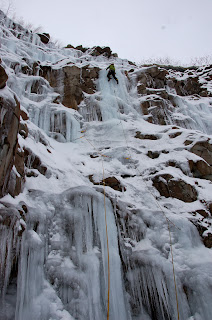
Starting up The Gift WI4 through the ice start


The good ice quickly faded as I continued up a snow ramp pulling off eyelids and exposing underlying sloping limestone defunct of edges. I tiptoed my way up to the next bit of "ice" that provided a few insecure screws and eventually an icicle worth slinging accompanied by a small 12" diameter column that seemed more solid than anything thus far. This set me off right across another sloping, snow encrusted ledge which crumbled and exposed more slick limestone for my feet.


The base of the short pillar and best ice on the route


I eventually reached somewhat solid ice a little higher up and the first good screws of the climb. A short 15' pillar ended at more snow covered limestone which provided a very exciting, hollowed ice and rock top-out.


Topping out the pillar


I slogged up through deep snow to the base of the lower angled ice above and found that it was melting out fast and poorly bonded. The true climbing was over and the quickly deteriorating ice above helped me decide that the route was finished at that point. I quickly set up the most secure belay I could muster and prepared to bring Laura up. She progressed up the climb enjoying every move. She found it to be boney and melting out quickly, as did I. We shared a brief moment at the belay and snapped a few photos for memories.


Self portrait of the happy couple at the anchor


I gently lowered Laura down supporting most of her body weight with mine, carefully trying not to involve the anchor if necessary. With Laura safely on the ground I quickly utilized the best ice available and built a V-thread and rapped down without sacrificing anything, but cord.


Laura says... How could you not smile after climbing "The Gift"


The climb was a great season opener and a lot of fun, but the unpleasant sounds of ice falling off the walls around us, we knew we overstayed our welcome. We packed up and snowshoed back to the car. I snapped a few photos of the deteriorating ice for giggles. We decided to name the route The Gift WI4R in current conditions. We decided it was "The Gift" from mother nature, since she didn't offer very favorable ice seasons the last several seasons. Hopefully this isn't all we'll get this season. Stay tuned...


Meltdown... a common sight today


Fractures common as well


Where's Waldo? Center of photo in the right chute

Monday, November 26, 2012

Strange orange moth


My husband photographed this gigantic orange moth on a recent business trip. Thankfully, something this odd is usually pretty easy to identify on the internet. It didn't take long to find out that this is a Regal Moth, also known as Royal Walnut Moth, Citheronia regalis.


It would be odd enough if it were the size of a normal moth. But according to Wikipedia, this is the biggest moth north of Mexico. (That's weight, not wing span, though that's not shabby either.) In this lighter wide-angle view, you can compare him to the door hardware to see how large he is.

This was on the door of the hotel, so maybe he's a watch-moth. I know several people who would hesitate to open that door!

-----

Updated:
This one was found in Virginia, but they are at home anywhere in the east, I believe.

Submitted to the Friday Ark.

Sunday, November 25, 2012

The Brinker Kinexxion

The following Deed Record was found on June 7, .. at the Family History Library in Salt Lake City. It was the occasion of an extremely happy “Happy Dance” for me, as reported by Carol several days later. You see, it had been many, many years since I've been able to add a new ancestor to my pedigree chart.


I was ecstatic, to put it mildly. I had finally found the maiden name (as well as the actual first name) of the mother of Elizabeth (Switzer) Yarian – Catharine Brinker – and the name of Catharine's father, Andrew!


Not only had I added a new ancestor, but, I didn't know it at the time, I would have the Brinker lineage several generations back to the early 1700s in Switzerland. It seems that extensive research has been done on the Brinker family by two ladies who have documented Andrew's parents and grandparents!


In addition, at least one book has been published on the Leatherman/Lederman family – the wife of Andrew Brinker was Barbara Leatherman.


Yes, those last two days before I left Salt Lake City on June 9th were filled with amazing revelations and I was busy gathering as much information as possible, barely even reading most of it at the time!


And this document, a Quit Claim Deed dated the 11th of August in 1849 was the catalyst for that research frenzy... the heirs of Catharine Sweitzer were “selling” 213 acres in section 12 Fairfield Township, Columbiana County, Ohio to Thomas McCoy for which he gave one dollar to each of them. I've added emphasis on specific "important" portions...

Daniel Deemer, etal to Thomas McCoy.
Know all men by these presents the we Daniel Deemer and Susan Deemer his wife, of the county of Columbiana, Jacob Mondwick and Barbara Mondwick his wife of the County of Portage, Peter Bubecker & Rebecca Bubecker his wife of the County of Mahoning, Jacob Yarian & Elizabeth Yarian his wife of the County of Portage for and in consideration of the sum of one dollar each to us severally in hand paid by Thomas McCoy of the county of Columbiana the receipt whereof is hereby Acknowledged, have remised, released, and forever quit claimed... all our right, title and interest both legal and equitable in and to the following described premises, situate in the county of Columbiana and state of Ohio, and being the South East corner or part of section number twelve, in township number twelve, in range number two in the district of land offered for sale at Steubenville. Beginning at the South East corner of said section then on West with the line of the same thirty chains and seventy five links to a post, thence North fifteen degrees West fifty chains and fifty nine links to a post on Peter Firestones line thence East thirteen chains & twenty five links to a post, thence North ten chains and eighty seven links to a post, thence East thirty chains to a post, on the Eastern boundary line, thence South with the section line fifty nine chains and seventy four links to the place of beginning. Containing two hundred & thirteen acres and forty two hundredths, be the same more or less. It being the tract or parcel of land willed & devised by Andrew Brinker late of Columbiana County, deced, to his daughter Catharine Switzer & her heirs & deeded by the executors of said Andrew to said Catharine. To have and to hold the aforesaid described premises with all the privileges and appurtenances unto the said Thomas McCoy his heirs and assigns forever, so that neither we the aforesaid grantors above named nor our heirs nor any other person or persons claiming by through or under us shall at any time hereafter by any ways or means have claim or demand any right or title to the aforesaid premises or appurtenance or any part thereof. In testimony whereof we have hereunto set our hands and seals this eleventh day of August A. D. 1849.
Signed, sealed and delivered in presence of us

Samuel Entrilkin

George W. Entrilkin
The deed was signed by Dr Daniel Deemer, Susannah Deemer, Jacob Morndick, Barbary Morndick, Peter Buckecker, Rebecca Buckecker, Jacob Yarian, and Elizabeth Yarian.


Received for record January 30th, 1850. And recorded on the second day of February following.

=+=+=+=+=+=+=+=+=+=+=+=+=+=+=+=+=+=+=+=+=+=

But there was one thing that really, really puzzled me about this transaction. Did you notice that I put the word selling in quotes in the paragraph prior to the deed transcription?


Why was the land sold to Thomas McCoy for so little – just one dollar paid to each of the heirs?


It seems I had overlooked another earlier deed recorded in volume 41, page 818. I had made note of it but not the name of the purchaser and I hadn't taken the time to view it while in Salt Lake City – I was concentrating on deeds that included “etal” with the grantors name! On my visit to Columbiana County I looked up the record and found that Jacob and Catherine had actually sold the land for $5,000 to Thomas McCoy. However, I neglected to write down the month and day of the transaction (I got in a hurry because the Recorders Office was extremely busy). The year was 1849. Most likely earlier than August 11th since it was recorded in an earlier volume than the other deed.


So, why?. If Jacob and Catherine sold the land to Mr. McCoy earlier in 1849 then why was there the second transaction with her heirs signing off on a Quit Claim deed? Catharine was still living – she didn't die until 1852. So, why?


I don't have an answer to that question. I'm just very glad that they did, otherwise I still might not know that Catherine Brinker was the mother of Elizabeth Yarian. Nor would I now have several more generations added to my ancestral pedigree chart!


Columbiana County, Ohio Deeds Volume 42, bottom of page 596 (FHL Film 926947)


Columbiana County, Ohio Deeds Volume 42 page 597 (FHL Film 926947)